Online Tool Provides Chicago Planners Way to Measure Accessibility to Jobs, Parks, Schools & Other Destinations
Resource From Urban Transportation Center at UIC Integrates Data for Easy Interpretation
Planners and policymakers in the greater Chicago area can now employ a recently-developed digital resource to better evaluate accessibility by four common transportation modes to many types of destinations in the urban environment and use that information to improve livability.
The Metropolitan Chicago Accessibility Explorer – accessed at http://urbanaccessibility.com — is a map-based web-tool covering metropolitan Chicago developed by researches from the Urban Transportation Center (UTC) at the University of Illinois at Chicago.
Download the research study, “The Metropolitan Chicago Accessibility Mapping Project.”
Access a PowerPoint presentation, Transit Accessibility, Last Mile Issues & Equity, related to this research.
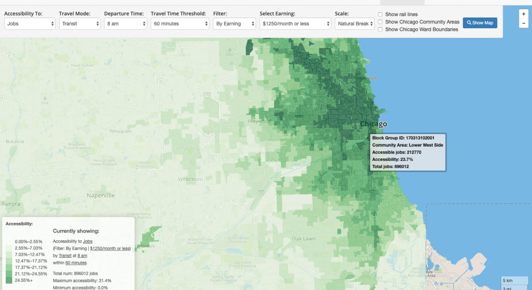
Through the Accessibility Explorer, planners, for example, can identify areas lacking access to jobs, parks, shopping, etc. and propose adjustments to transit service or land use to address these shortages. Drop down options let users access a visual display of the number of jobs by specific industry, public and private schools, hospitals, parks, libraries, fire stations and grocery stores a person can reach in a prescribed amount of time via public transportation, private auto, by bicycle or on foot.
The tool allows users to gauge accessibility to Chicago neighborhoods, suburbs or other parts of the metropolitan area using different modes of transportation. The tool measures accessibility by summing up the number of opportunities that can be reached from each location by different modes. To develop the tool, researchers measured travel times for transit, auto, bicycle, and pedestrian modes, collected land use data from various federal, state, county and local governments and agencies, and integrated the data so it could be interpreted easily.
Four options are available when searching for jobs: auto, transit, bike and walk. When selecting the auto and transit options, the results represent percentage of jobs reached in a specified timeframe from each location. The weighted accessibility option provides data for the percentage of households in the search area that don’t own cars.
The Accessibility Explorer site and related research were prepared by Dr. Nebiyou Tilahun, Shi Yin, Moyin Li and Yaye Keita. The project was funded by the Metropolitan Transportation Support Initiative (METSI) and the National Center for Transit Research.